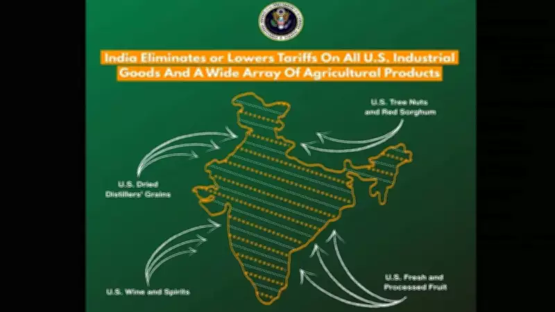
US Trade Office Deletes Controversial X Post on Indian Territory Map
The Office of the United States Trade Representative (USTR) has taken down a social media post from its official account on the platform X, formerly known as Twitter. The post, which was published on February 11, 2026, featured a map that showed Pakistan-occupied Kashmir (PoK) and Aksai Chin as integral parts of Indian territory. This action has drawn significant attention due to the sensitive nature of territorial disputes in the region, particularly between India and its neighbors.
Details of the Controversial Post
The now-deleted post was part of a broader communication by the USTR, likely related to trade discussions or policy announcements. However, the inclusion of the map, which depicted PoK and Aksai Chin within India's borders, quickly became the focal point. PoK is a region administered by Pakistan but claimed by India, while Aksai Chin is a disputed area controlled by China but also claimed by India. The portrayal of these areas as Indian territory is a contentious issue that touches on long-standing geopolitical conflicts.
The removal of the post occurred shortly after it was published, suggesting that the USTR may have realized the diplomatic implications. Officials have not provided an official statement explaining the deletion, but it is widely speculated that the move was aimed at avoiding unintended political fallout or misrepresenting US policy on territorial matters.

Diplomatic Sensitivity and Regional Implications
This incident underscores the delicate balance that international bodies, including US government agencies, must maintain when addressing territorial disputes. India has consistently asserted its sovereignty over PoK and Aksai Chin, while Pakistan and China hold opposing views. Any public depiction by a foreign entity can be interpreted as taking a stance, potentially complicating diplomatic relations.
The timing of the post and its swift removal highlight the challenges of digital diplomacy in an era where social media posts can quickly escalate into international incidents. It also reflects the broader context of US-India relations, which have been strengthening in recent years through trade partnerships and strategic alliances, particularly in countering Chinese influence in the Indo-Pacific region.
Reactions and Analysis
While there has been no formal response from the Indian or Pakistani governments regarding this specific incident, analysts note that such maps often provoke strong reactions. In the past, similar depictions have led to diplomatic protests or calls for clarification. The USTR's decision to take down the post may be seen as a precautionary measure to prevent any misunderstandings or tensions.
Key points to consider include:
- The map in the post showed PoK and Aksai Chin as part of India, contrary to the positions of Pakistan and China.
- The deletion suggests the USTR recognized the potential for the post to be misinterpreted or cause diplomatic strain.
- This event illustrates how social media platforms are increasingly used for official communications, requiring careful vetting to avoid geopolitical missteps.
In conclusion, the removal of the X post by the US Trade Representative's office serves as a reminder of the intricate web of territorial claims in South Asia. It emphasizes the need for precision in international communications, especially when dealing with sensitive issues like border disputes. As digital diplomacy evolves, such incidents may become more common, highlighting the importance of clear policies and oversight in government social media use.