When the ground stopped shaking on the southern coast of the Philippines, the sea had moved. Beaches that families had known all their lives were suddenly hundreds of feet from the water. Coral reefs that had been submerged for generations were now exposed to the air, baking in the sun.
This is the real, documented aftermath of a 7.8-magnitude earthquake that struck the island of Mindanao on June 8, 2026. According to the Philippine Institute of Volcanology and Seismology, the country's official earthquake monitoring agency, the quake’s epicenter was offshore near Sarangani province and linked to activity along the Cotabato Trench, one of the region’s most seismically active fault systems. The trench had already generated a swarm of thousands of mostly small tremors back in January, a pattern a United Nations disaster risk report in May identified as a potential warning sign of a bigger quake to come.
In the US, earthquakes are generally thought of as shaking buildings and cracked roads. In Mindanao, what happened adds a stranger, more permanent twist: the land itself rose from the sea.

When the seafloor becomes the shoreline
Arsenio Butil Jr., a fisherman and pastor in Glan municipality in Sarangani who lived through it, said the tremor was the strongest he had ever felt. According to him, the water receded from the shore, then returned, then receded several times again in a row, as fish died and floated on the surface. Families are staring at a coast they do not recognize.
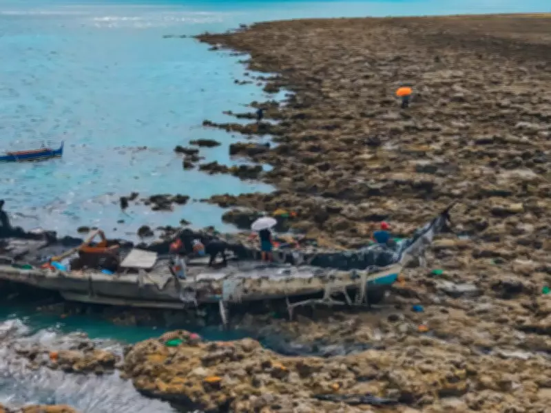
What he was seeing had a name: coastal uplift. According to PHIVOLCS, it happens when a big earthquake in a subduction zone, a place where one part of the Earth’s crust slides under another, suddenly releases pressure that has built up over years. That release can raise the seafloor several feet in seconds.
In some areas, the seafloor near the worst-hit coastal towns rose by about two meters, or about six and a half feet, pushing the shoreline outward by as much as 200 meters, or about 650 feet. What was once ocean is now dry land, at least for the foreseeable future.
This might not be unique to the Philippines. The same fundamental process occurs along subduction zones around the world, including the Pacific coast of the United States. A major quake along the Cascadia fault, which runs from Northern California to British Columbia, could cause several feet of sudden land deformation along the coast, instantly changing shorelines and flood risk, according to the U.S. Geological Survey. The difference is that Cascadia’s deformation is expected to mostly lower the coast rather than lift it, a reminder of how local these shifts can be.
A coastline residents no longer recognize
The uplift has not been a geological curiosity for residents on the southern fringe of Mindanao. It has felt like losing a little piece of home. Nane Danlag of the Philippines' seismology center said the change is essentially permanent. What residents are looking at now, she said, is their new coastline, forged by the same tectonic forces that have moved this region for thousands of years. Lives lost, land reshaped.
Datu Atom Malimpnig, a local chieftain sheltering with about 100 evacuated residents in a hillside encampment, said many in the group believe the rising seafloor is a warning sign that a tsunami could still come. That fear is not unreasonable. According to Butil, long cracks have opened in the ground near his community, and they would make another strong quake especially dangerous.
What this means beyond the disaster itself
There is also an economic and ecological cost that is easy to forget in the broader coverage of the disaster. The exposed coral and shallowing of the water have made the coastline less conducive to swimming and beach tourism, which local businesses rely on, as the sea has become too shallow, said Edzel Baylon, a staff member at the Isla Jardin del Mar resort.
It is a reminder that earthquakes do not only damage what is built on land. They can permanently rewrite the geography on which people have built their lives and livelihoods.
For now, residents in the hardest-hit towns are not thinking about rebuilding yet. Many are just trying to figure out if it is safe to return home at all, with the ground still fractured in places and aftershocks still rocking the region.