
Gurgaon Implements Digital Geofencing to Safeguard Sultanpur National Park
In a significant move to protect the eco-sensitive zone (ESZ) of Sultanpur National Park (SNP) in Gurgaon, authorities have launched a digital geofencing plan, marking its entry into the execution phase. This initiative comes as urban pressures, including illegal constructions and encroachments, continue to mount around the park, threatening its delicate ecosystem.
Addressing Violations with Technology
The decision to digitize monitoring follows a persistent pattern of violations reported in recent years around the park. Officials emphasize that this technology will generate time-stamped evidence of violations, thereby strengthening legal and regulatory actions against offenders. Key measures include a ban on mobile towers within 3 kilometers, prohibition of new wood-based industries in the vicinity, and no construction allowed within 300 meters of the park boundary.
To enforce these rules, the plan involves deploying cameras on all watch towers and launching drones across the sanctuary. Divisional Wildlife Officer (DWO) RK Jangra stated that the department aims to complete the project within this year, with technical assistance being sought and preliminary groundwork already finalized.

Mapping and Implementation Details
The eco-sensitive zone around Sultanpur Park spans 5 kilometers and includes 22 villages. Mapping of the outermost ring has commenced, and the rollout timeline for the alert system is set to be finalized within 15 days. The Haryana Space Applications Centre will lead the geospatial work, while an alert dashboard will notify enforcement teams immediately upon detecting any violations.
Previous reports have highlighted the presence of banquet halls, ornate entrance gates, and both commercial and residential structures emerging near the park boundary. Once operational, the geofencing framework is expected to automatically flag unauthorized activities, enabling quicker field-level interventions.
Historical Context and Environmental Concerns
A committee constituted by the National Board for Wildlife (NBWL) flagged at least 78 instances of unauthorized construction within the ESZ last September. In December alone, forest officials recorded 32 fresh violations, with over a dozen construction projects underway within meters of the protected area. These activities raise serious concerns about disturbances to the wetland's hydrology and bird habitats.
Forest department officials position the geofencing initiative as a long-term solution to ensure sustained oversight as urbanization intensifies. Environmentalists have repeatedly warned that continued construction pressure could irreversibly damage one of the National Capital Region's most important bird habitats.
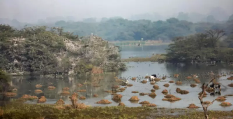
Enhancing Monitoring and Enforcement
The geofencing framework is designed to enable sharper, real-time monitoring of land-use changes and construction activities around the protected wetland. This area has remained vulnerable to violations amid Gurgaon's expanding urban footprint. The ESZ functions as a critical buffer for the park's wetland and grassland ecosystem, which supports tens of thousands of migratory waterbirds every winter.
Officials acknowledge that unclear boundary demarcation and reliance on manual monitoring have historically hampered enforcement efforts. The new technology is expected to address these gaps by creating a clearly defined digital boundary backed by satellite imagery and ground-verified data, providing a robust tool for conservation.


