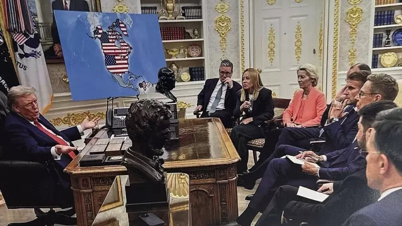
Former US President Donald Trump has sparked international attention by sharing a new American map. This map includes the Arctic territory of Greenland as part of the United States.
Controversial Territorial Claims
Trump posted the map on his social media platform. It shows Greenland labeled as "US territory, Est. 2026." The map also incorporates portions of Canada and Venezuela into American borders.
AI-Generated Imagery
In a separate post, Trump shared an AI-generated picture. This image depicts him planting the US flag on land marked as Greenland. Vice President JD Vance and Secretary of State Marco Rubio appear alongside him in the visual.

The text on the land clearly reads "Greenland, US territory, Est. 2026." This digital creation presents a futuristic scenario of American expansion.
Global Reactions
The posts have generated significant discussion worldwide. Observers note the inclusion of Canadian and Venezuelan territories adds to the controversy. These claims challenge existing international boundaries and sovereignty.
Trump's actions highlight his continued influence on political discourse. The use of AI technology for such imagery marks a notable development in political communication.
The year 2026 serves as the proposed establishment date for this territorial change. This timeline suggests a forward-looking, albeit speculative, vision for US geography.
Historical Context
Greenland has been a Danish autonomous territory for centuries. Previous US administrations, including Trump's first term, expressed interest in purchasing Greenland. Denmark firmly rejected those overtures.
This latest map revives those discussions in a dramatic fashion. It presents a visual assertion of American control over the strategically important Arctic region.
The map's publication underscores ongoing geopolitical tensions. Arctic resources and shipping routes remain subjects of international competition.