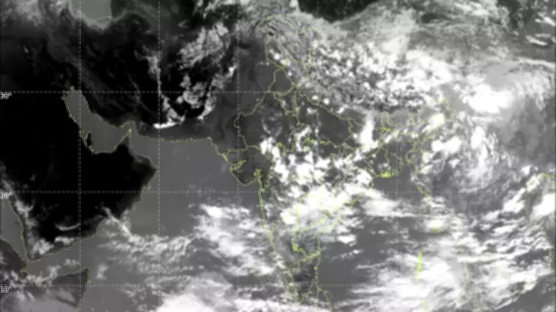
Satellite images captured on June 27, 2026, show largely clear skies over most parts of India, even as the India Meteorological Department (IMD) officially declared the advance of the southwest monsoon over the country. The unusual clarity in the skies has raised concerns about rainfall deficits and potential drought conditions in several regions.
IMD Declaration vs. Ground Reality
The IMD had announced the onset of the southwest monsoon over most parts of India, which typically brings widespread rainfall. However, satellite imagery from the past few days indicates that cloud cover is sparse, and many areas are experiencing clear skies. According to meteorologists, this discrepancy suggests that the monsoon's progress has stalled or weakened.
"The satellite images clearly show that the monsoon clouds are not as extensive as expected for this time of year," said a senior IMD official on condition of anonymity. "This could lead to a delay in rainfall over key agricultural regions."

Impact on Agriculture and Water Resources
The clear skies are particularly concerning for farmers who rely on monsoon rains for sowing crops like rice, cotton, and sugarcane. The lack of adequate rainfall could affect crop yields and exacerbate water scarcity in drought-prone areas. As of June 27, 2026, rainfall across India is 23% below the long-period average, according to IMD data.
"We are closely monitoring the situation and have advised states to prepare for contingency measures," added the official. "If the dry spell continues, it could impact the kharif season."
Possible Causes of the Monsoon Deficit
Meteorologists attribute the current dry spell to a weak monsoon trough and the presence of anti-cyclonic circulation over central India. These factors are suppressing cloud formation and rainfall. Additionally, the El Niño phenomenon in the Pacific Ocean is known to weaken the Indian monsoon, and its effects may be contributing to the current situation.
"El Niño conditions are prevailing, and that typically reduces monsoon rainfall over India," explained Dr. R. Krishnan, a climate scientist at the Indian Institute of Tropical Meteorology. "The satellite images are consistent with a weak monsoon phase."
Regional Variations in Rainfall
While most of India shows clear skies, some regions have received isolated rainfall. The northeastern states and parts of the western coast have experienced near-normal precipitation, but central and northern India remain dry. The IMD has issued forecasts for scattered showers in the coming days, but significant relief is not expected immediately.
The clear skies are also leading to higher temperatures, with several cities recording temperatures above 40°C. The combination of heat and dry conditions has prompted health advisories in some areas.
Government Response and Advisory
The government has urged farmers to delay sowing until rainfall picks up and has advised states to ensure adequate water supply for drinking and irrigation. The Ministry of Agriculture is reviewing contingency plans for drought-affected districts.
"We are in constant touch with the IMD and state governments to assess the situation," said a spokesperson for the Ministry of Agriculture. "Our priority is to minimize the impact on farmers and food production."
As the monsoon season progresses, all eyes are on the skies, hoping for a revival of the rains that are crucial for India's agrarian economy.